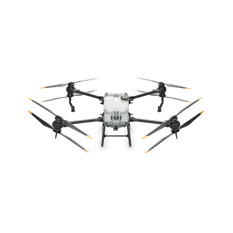
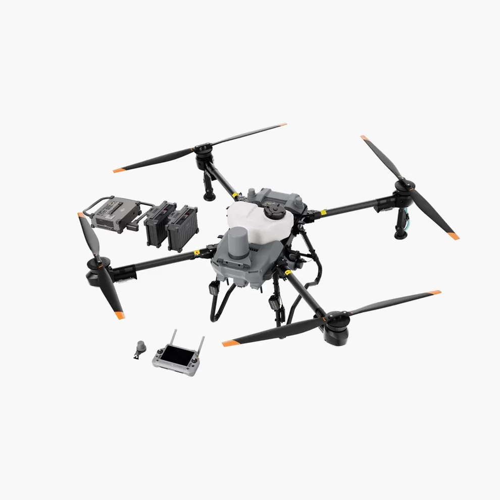
Farming Smithsburg
Schedule A Demo
Your Mid Atlantic Top Rated Agricultural Spraying Drone Company serving Pennsylvania, Maryland, Virginia & Delaware. Our service is state of the art technology that saves you time and money & our support team is top notch and never leave you alone. We proudly serve the Mid-Atlantic Farmers and Crop growers!
Keywords Drone Dealer, Mid Atlantic Drone Dealer, Crop spraying drones, Agriculture spraying drones, Crop drone spraying, Crop drones for spraying, Agriculture spraying using drones, Agriculture drones, Drone Solutions, Drone Service, Drone Support, DJI AGRAS T30 Spraying Drone, Agricultural Spraying Drone company, DJI AGRAS T40, DJI AGRAS T50, DJI Mavic.
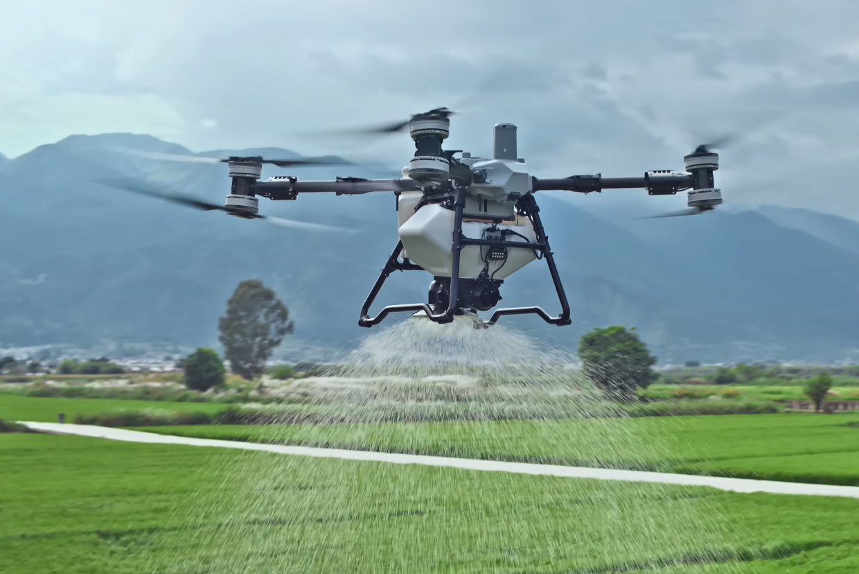
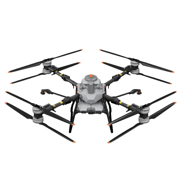
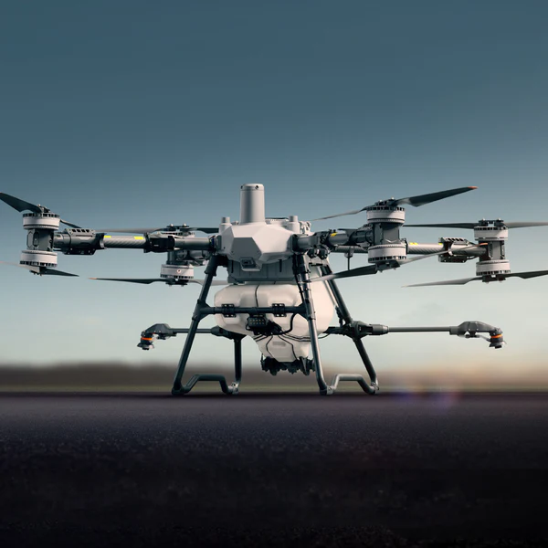
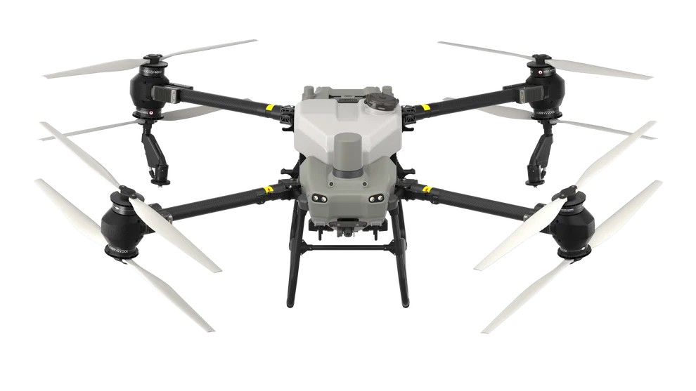
52 acres per flight hour 10.56 gallons spray tank 12-megapixel adjustable camera 36 ft Swath (Spray Width) Centrifugal Nozzles Coaxial Twin Rotor -- Prepare for a paradigm shift in precision agriculture with the impending launch of the DJI Agras T50. This formidable aerial vehicle is tailored for farmers, crop dusting businesses, and agronomists who demand excellence, efficiency, and reliability. Robust Design, Exceptional Performance: The DJI Agras T50 is not just another drone; it is a heavyweight champion in the agricultural sprayer drone sector. With an empty weight of 39.9 kg (88 lbs) and a gross takeoff weight of 52 kg (114.64 lbs) including the battery, the T50 is engineered to handle significant payloads with ease. When fully equipped for spraying operations, it takes to the skies at a max takeoff weight of 92 kg (202.83 lbs), and for spreading tasks, it rises with 103 kg (227.08 lbs). Dimensions of Might and Maneuverability: This drone's expansive diagonal wheelbase stretches to 2200 mm (86.61 inches), and its dimensions are as follows: Arms and propellers unfolded: 2800×3085×820 mm (110.24×121.46×32.28 inches) Arms unfolded, propellers folded: 1590×1900×820 mm (62.60×74.80×32.28 inches) Compact and storage-friendly with arms and propellers folded: 1115×750×900 mm (43.90×29.53×35.43 inches) Precision at Its Core: The Agras T50 boasts a hovering accuracy range that is second to none. With D-RTK enabled, it hones in on its target with a horizontal and vertical precision of ±10 cm (±3.94 inches). Even with D-RTK disabled, it maintains an impressive horizontal accuracy of ±60 cm (±23.62 inches) and a vertical precision of ±30 cm (±11.81 inches), ensuring your crops receive the care they deserve, every time. Spraying System with Unmatched Range: Embrace the efficiency with a 40 L (10.56 gallons) spray tank and an operating payload of 40 kg (88.18 lbs). The T50's dual sprinklers (Model: LX8060SZ) deliver droplets ranging from 50-500 μm, reaching an effective spray width of 4-11 m (13.12-36.09 ft), even at a height of 3 m (9.84 ft) above crops, achieving unparalleled coverage. Advanced Radar and Vision Systems: Navigate with confidence with the T50's phased array radar system and a binocular vision system that safeguards your flight from every angle. Its obstacle avoidance system and multidirectional sensing range ensure safe operation across your fields, even in complex terrain. Command with Clarity: Control is in your hands with the T50's RM700B model remote controller, featuring a 7.02-inch LCD touchscreen with 1920×1200 resolution and brilliant brightness, facilitating operation from dawn till dusk. Seamless Connectivity: Harness the power of Wi-Fi 6 and Bluetooth 5.1, ensuring stable and reliable connections, even in the most remote areas. Product Specifications Spray System 10.5-gallon liquid tank designed to empty in under 3 minutes Estimated 36-foot swath with pattern consistency across the entire swath Up to four rotary style nozzles spray through centrifugal force rather than pressure, making adjusting droplet size as easy as clicking a button Magnetic drive impeller pump with up to 6.34 gal/min (4 nozzles) and 4.23 gal/min (2 nozzles) Live level meter, in addition to on-board scales, provide readings of the remaining volume of liquid in tank signaling time remaining in field Spreader System 19.8-gallon spreader tank designed to hold 110 lbs of granular material Get higher spreading efficiency with the spiral channel spinner disk A jam-free, high-torque spreading motor Efficiency & Operations Improved terrain following ability with up to 50° in spraying/spreading missions 2 sets of binocular vision and 2 omnidirectional radars helping to achieve maximum efficiency terrain following and obstacle bypassing 12 mega-pixel camera with adjustable angles for a smooth and crisp view 4 aircraft image transmission antennas Complete mapping capability Whole field coverage - up to 50 acres per hour at 2 GPA Up to 5 gal/acre while still maintaining 32 ft/sec with a swath of 32 feet Ability to operate continuously with 3 batteries, 1 charger and a generator on site
Video: DJI Agras T50
Link: DJI Agras T50
25 to 35 acres per flight hour 10.56 gallons spray tank 12-megapixel adjustable camera 30 ft Swath (Spray Width) Centrifugal Nozzles Coaxial Twin Rotor The DJI Agras T40 sprayer drone sprays up to 35 acres in one flight hour. This drone has four arms; however, on each arm, there are two motors and two pairs of propellers (54 inches props). Payload Capacity The DJI Agras T40 has a liquid payload of 10.56 gallons. The tank can hold pesticides, herbicides, fungicides, and other liquid chemicals. Most of the Agras sprayer drone users spray between 1 to 5 gallons per acre which is a much more concentrated than used in ground applications. If you spray 2 gallons per acre, the DJI Agras T40 tank can hold enough liquid to spray up to five acres in one flight. Dual Atomized Centrifugal Nozzles The all-new dual atomized centrifugal nozzles have two spinners that make the droplets more uniform in size, avoid splashing, and dripping, and prevent clogging when spraying powder-based chemicals. Local Map Creation For the first time, the Agras T40 has a 12-megapixel camera with an adjustable gimbal to take high-quality pictures of the field while flying, and Agras T40's remote controller can process the images in real-time. Battery The Agras T40 battery can be charged in about 10 minutes when the charger is connected to a 240-volt outlet. The Agras T40 battery has a warranty of 1 year / 1,500 Charging cycles Magnetic Drive Impeller Pump Updated Magnetic drive Transmission Impeller Pumps of the Agras T40 have a flow rate of 12L/min. The new DJI pump design separates the pump motor and the fluid to provide a zero-corrosion pump. 110 lbs Spreader Attachment The Agras T40 Spreader can carry 110 lbs of dry material and has a 18.5 gallon tank. The T40 spreader's new lid is much larger, which increases the spreading efficiency by reducing the refilling time. Improved Obstacle Avoidance System The new active phased array radar of the Agras T40 has a 164 ft detection range. In addition to the mentioned radar, the Agras T40 is equipped with a binocular vision system that allows 3D terrain mapping and optimal bypassing of obstacles.
Video: DJI Agras T40 Sprayer Drone
The DJI Agras T25 is an advanced agricultural drone designed for precision crop protection. With a robust build and intelligent features, it revolutionizes the way farmers manage their fields. Key highlights include: Payload Capacity: The T25 can carry a spraying payload of up to 20 kg or a spreading payload of up to 25 kg. This impressive capacity allows efficient application of fertilizers, pesticides, and seeds. Efficient Operation: Equipped with a high-precision spraying system, the T25 ensures accurate and uniform coverage. Its intelligent flight planning optimizes routes, minimizing overlap and reducing operational time. Advanced Sensors: The drone features multispectral sensors for crop health monitoring. Real-time data helps farmers identify areas requiring attention and adjust treatments accordingly. Durability and Reliability: The T25’s rugged design withstands challenging field conditions. Dual batteries provide extended flight time, allowing coverage of larger areas. User-Friendly Interface: The intuitive DJI Terra software simplifies mission planning and data analysis. Farmers can make informed decisions based on actionable insights.
Video: DJI Agras T25
Link: DJI Agras T25
A lightweight, hard-working thermal drone With the Mavic 3 Enterprise lineup, DJI started from their most popular drone platform, the Mavic 3, and updated it for commercial applications. The new Mavic 3 Thermal Enterprise offers a cost-efficient solution for a range of industry needs, from industrial inspection to surveying and mapping. This drone flies fast and smooth while it captures detailed visual and thermal footage with its professional-grade tri-camera system. And it can be deployed quickly, helping you complete jobs efficiently to save your team time and labor. Twin 4K cameras The Mavic 3T features a pair of 4K visual cameras for added flexibility. The primary wide camera has a 48-megapixel, 1/2" CMOS sensor that gives you greater resolution and clarity. And its wide field of view lets you capture more in every frame. The secondary telephoto camera has a 12-megapixel, 1/2" CMOS sensor and supports up to 56X hybrid zoom. This helps you scout out the terrain and zoom in to capture detailed footage from a distance. This is especially helpful for industrial inspections, where you need your drone a safe distance away from power lines and other obstacles. See in visual, thermal, or both The Mavic 3T supports 640 x 512 thermal resolution with highly accurate spot and area temperature measurement. You can customize your view with alerts for high temperatures, isotherms, and several different color palettes like white hot, iron red, and medical. This allows the drone to aid emergency response applications like firefighting and search and rescue. You can switch between each camera on the fly, letting you choose the best view in real-time as your needs change during an operation. Even better, the 3T supports a split-screen view of your thermal and visual feeds at the same time. This lets you make quick comparisons and simultaneously zoom both feeds up to 28X for a closer look. Smart flight protects your investment This drone's advanced obstacle detection means flyers can keep themselves and their drone at a safe distance when performing complex or otherwise dangerous operations. The drone's Advanced RTH (Return to Home) feature can even automatically plot a safe course back to you at the press of a button or if the signal is lost. Strong transmission, stable controls Getting a fuzzy feed or losing video connection entirely mid-flight can scuttle a mission and needlessly set your team back. Luckily, the Mavic 3T uses Enterprise OcuSync 3.0 (O3), DJI's impressive transmission system. This wireless technology automatically switches between two different bands (2.4 GHz and 5.8 GHz) to resist pesky interference and provide reliable high-definition video transmission. OcuSync's low-latency transmission gives you high-definition video feeds at 30 frames per second, and it keeps your control of the drone sharp and responsive. With a range up to 9.3 miles, you also have some serious flexibility. You team can confidently fly the drone on missions over mountains, ravines, and other obstacles — all while their feet are placed safely on terra firma. DJI Mavic 3T Enterprise quadcopter with Care Basic Comes with the RC Pro Enterprise controller, an extra pair of propellers, and protective case. Intuitive controls and software The included RC Pro Enterprise remote controller comes with DJI Pilot 2 built-in, DJI's updated and improved flight interface. Flight and navigation details are displayed clearly on the controller's bright, 5.5-inch touchscreen. The Mavic 3T is also compatible with FlightHub 2. This project management software allows for simultaneous collaboration between multiple teams working on the same project with live mission streaming. Users can even add live annotations for the drone operator to respond to for efficient coordination. Third-party support With an open-source SDK (software developer kit) you can develop custom apps and benefit from the work put together by the wider drone community. This means you can create or take advantage of third-party tools and services, helping you expand and refine your drone's capabilities. Support includes the hardware of the drone itself, but also payloads and cloud platforms. Top-notch security You can opt to store your data locally on the drone or an SD card. Both encrypt your data with password protection, and that password isn't stored anywhere on DJI's end. This means if the drone crashes or is lost, no one will be able to retrieve the data without your password. If need be, you can also erase all of your data on the drone with a single tap in the DJI Pilot 2 interface. Product highlights: quadcopter with 20-megapixel wide camera, 12-megapixel telephoto camera
Link: DJI Mavic 3 Thermal
DJI Mavic 3 Multispectral, also known as DJI Mavic 3M or DJI M3M, has replaced the Phantom 4 Multispectral for multispectral and NDVI mapping. The combination of the Mavic 3 Multispectral with a DJI Agras drone will increase the spraying precision and makes the prescription spraying mission possible. The prescription spraying missions allow Agras users to spray a larger dosage on the affected areas with a lower NDVI index and spray less amount on the healthy part of a field that has a higher NDVI index. This is all possible with the help of the DJI Mavic 3 Multispectral drone. Effective aerial surveying needs to see the invisible. That's why Mavic 3 Multispectral has two forms of sight. It combines an RGB camera with a multispectral camera to scan and analyze crop growth with total clarity. Agricultural production management requires precision and data, and Mavic 3M delivers both. Multispectral + RGB imaging system The highly integrated imaging system Newly upgraded imaging system with one 20MP RGB camera and four 5MP multispectral cameras (green, red, red edge, and near-infrared). Enables applications such as high-precision aerial surveying, crop growth monitoring, and natural resource surveys. Sunlight Sensor The built-in sunlight sensor captures solar irradiance and records it in an image file, allowing for light compensation of image data during 2D reconstruction. This results in more accurate NDVI results, as well as improved accuracy and consistency of data acquired over time. RTK module Accurate images that capture every pixel Mavic 3M with RTK module for centimeter-level positioning. Flight control, the camera, and the RTK module sync in microseconds to accurately capture the location of each camera's imaging center. This enables Mavic 3M to do high-precision aerial surveying without using ground control points. Efficient and reliable battery life Ultra-long battery life, fast bursts of 43 minutes*, Cruise time 200 hectares**. A single flight can complete mapping operations over an area of 200 hectares. Stable signal, smooth image transmission The O3 transmission integrates two transmitting signals and four receiving signals to support 15km ultra-long transmission distances. Omnidirectional obstacle sensing, terrain-follow aerial surveying The aircraft features multiple wide-FOV vision sensors that accurately detect obstacles in all directions for omnidirectional obstacle avoidance. The terrain-follow aerial surveying can be easily performed in steep-slope landscapes. *Specific test conditions: In a sunny environment without wind, the orthographic flight aerial photography is obtained with a flight speed of 15 m/s, a flight altitude of 217 m, a ground sampling distance (GSD) of 5.73 cm for visible and 10 cm for multispectral, a fore-and-aft overlap rate of 70%, and a side overlap rate of 60%. **Data was measured using a DJI Mavic 3M flying at a constant speed of 36 kph at sea level in a windless environment until 0% power remaining. It is for reference only. Please pay attention to Return to Home prompts on the DJI Pilot 2 app during the flight.
Loading map...